Clear Creek Canyon Road climbs into the Markagunt Plateau within the Cedar City Ranger District of the Dixie National Forest. The route follows a wide forest road up through the canyon to Clear Creek Pass, passing several open spots along the way that work well for camping. It's an easygoing drive that suits a wide range of vehicles and makes a good half-day trip or overnight base camp.
At the pass, the road meets a much narrower route that continues down the far side of the plateau. That section is restricted to vehicles under 72 inches wide and is a separate trail, not part of this drive. Clear Creek Road itself stays open and easy the entire way, ending with wide views out over the surrounding country.
Trail Summary
- Location: Parowan, Utah, off Highway 143 in the Dixie National Forest
- Distance: 5.8 miles
- Difficulty: 1
- Elevation: From 8,422 feet to 9,861 feet, a change of 1,439 feet
- Travel Time: 44 minutes
Difficulty
Suitable for high clearance 2WD
Stock equipment is all this drive needs, with no special gear required. The dirt road holds a gentle grade with good traction the entire way from the trailhead to Clear Creek Pass, with only minor rocks, dips, or ruts to watch for. Several open pull-offs sit along the route for camping, some large enough for four or five rigs with trailers, others smaller and shaded for two or three. One stretch partway up is called out as an easy, level one section in its own right. Full-size rigs should turn around at the pass, since the road beyond that point narrows and is restricted to vehicles under 72 inches wide.
Terrain
Clear Creek Canyon Road runs as a maintained forest service dirt road for its full length, wide enough for two vehicles through most of the drive. It climbs steadily through the canyon, opening into level, sun-exposed areas as well as a few shaded pull-offs along the way. The road passes close to private property in a couple of spots without crossing onto it, and holds a consistent, predictable surface all the way to Clear Creek Pass.
Highlights
Clear Creek Pass caps the drive with views across the Markagunt Plateau toward Yankee Meadows Reservoir, Parowan Gap, and the mountains of Nevada on a clear day. Parowan below was settled by Mormon pioneers in 1851, and the nearby Parowan Gap is known for its Native American petroglyphs. From the pass, a much narrower trail drops down the far side of the plateau, but it's restricted to vehicles under 72 inches wide and lies outside this route. The mix of open and shaded campsites along the way makes this a solid option for an overnight stay.
Map
Waypoints
 |
Waypoint 1 (37.7221° N, 112.6678° W) |
 |
Waypoint 2 (37.7273° N, 112.6865° W)This marks the start of Clear Creek Canyon Road, Forest Route 30050. |
 |
Waypoint 3 (37.7273° N, 112.6865° W)This marks the start of Clear Creek Canyon Road, Forest Route 30050. |
 |
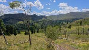
Waypoint 4 (37.7324° N, 112.7003° W)An open, unshaded campsite here with room for four or five rigs, trailers included. |
 |
Waypoint 5 (37.7324° N, 112.7003° W)An open, unshaded campsite here with room for four or five rigs, trailers included. |
 |
Waypoint 6 (37.7384° N, 112.7022° W) |
 |
Waypoint 7 (37.7384° N, 112.7022° W) |
 |
Waypoint 8 (37.7388° N, 112.7185° W) |
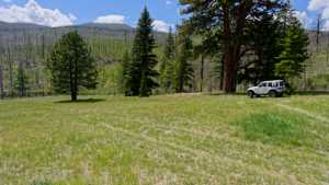 |
Waypoint 9 (37.7432° N, 112.7218° W)A shaded camping spot for two or three rigs, close to private property but not on it. |
 |
Waypoint 10 (37.7432° N, 112.7218° W)A shaded camping spot for two or three rigs, close to private property but not on it. |
 |
Waypoint 11 (37.7451° N, 112.7226° W) |
 |
Waypoint 12 (37.7483° N, 112.7446° W)Clear Creek Road tops out here at the pass, with views stretching to Yankee Meadows Reservoir, Parowan Gap, and the mountains of Nevada. |
 |
Waypoint 13 (37.7483° N, 112.7446° W)Clear Creek Road tops out here at the pass, with views stretching to Yankee Meadows Reservoir, Parowan Gap, and the mountains of Nevada. |
 |
Waypoint 14 (37.7483° N, 112.7446° W)Clear Creek Road tops out here at the pass, with views stretching to Yankee Meadows Reservoir, Parowan Gap, and the mountains of Nevada. |
 |
Waypoint 15 (37.7483° N, 112.7446° W)Clear Creek Road tops out here at the pass, with views stretching to Yankee Meadows Reservoir, Parowan Gap, and the mountains of Nevada. |
 |
Waypoint 16 (37.7483° N, 112.7446° W)Clear Creek Road tops out here at the pass, with views stretching to Yankee Meadows Reservoir, Parowan Gap, and the mountains of Nevada. |
 |
Waypoint 17 (37.7483° N, 112.7446° W)Clear Creek Road tops out here at the pass, with views stretching to Yankee Meadows Reservoir, Parowan Gap, and the mountains of Nevada. |
 |
Waypoint 18 (37.7483° N, 112.7446° W)Clear Creek Road tops out here at the pass, with views stretching to Yankee Meadows Reservoir, Parowan Gap, and the mountains of Nevada. |
 |
Waypoint 19 (37.7483° N, 112.7446° W)Clear Creek Road tops out here at the pass, with views stretching to Yankee Meadows Reservoir, Parowan Gap, and the mountains of Nevada. |
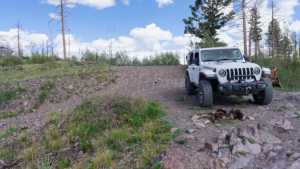 |
Waypoint 20 (37.7483° N, 112.7446° W)Clear Creek Road tops out here at the pass, with views stretching to Yankee Meadows Reservoir, Parowan Gap, and the mountains of Nevada. |
 |
Waypoint 21 (37.7486° N, 112.7401° W) |