Second Left Hand Canyon follows an old forest road up from Utah State Route 143 into a canyon of red hoodoo formations and spruce forest below Brian Head, in the Cedar City Ranger District of Dixie National Forest. The route climbs steadily along the canyon bottom, crosses a seasonal creek, and works its way past a stretch of terrain reshaped by wildfire before continuing up onto the plateau above.
The lower canyon is shaded and scenic, narrowing into a couple of short shelf sections as it gains elevation. Above the canyon, the trail opens into wide views across the Markagunt Plateau before reaching some of the higher ground in the area.
Trail Summary
- Location: Brian Head, Utah (off UT-143)
- Distance: 14.5 miles
- Difficulty: Level 4
- Elevation: From 6,682 to 10,457 feet with a 3,775 foot change
- Travel Time: 1 hour 52 minutes
Difficulty
Typically challenges the limits of a high clearance 4x4
Low-range gearing helps here, and undercarriage damage is a real possibility if you're not paying attention. Most of Second Left Hand Canyon is a manageable dirt and gravel road, but partway up there's a washout that's the crux of the drive: a narrow, off-camber cut roughly two feet deep. Short-wheelbase rigs get through it without much trouble, but longer vehicles should stop and look it over first, and everyone should take it slow since there's a real chance of tipping if a tire finds the wrong spot. Outside of that washout, expect a couple of short, narrow shelf sections with a slight off-camber lean, but nothing that approaches the washout in difficulty.
Terrain
The lower canyon starts on pavement for about the first half mile before switching to gravel and dirt. A shallow creek crossing comes up early, then the road climbs steadily along the canyon bottom, passing through a stretch of forest burned in the 2017 Brian Head Fire. Higher up, the road narrows into a couple of short shelf sections with a bit of off-camber lean, followed by the washout that's the main obstacle on this route. The upper portion opens into rolling terrain as the road gains the plateau, with a second, longer shelf section near the top.
Highlights
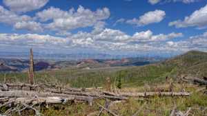
The burned timber partway up the canyon is a visible reminder of the 2017 Brian Head Fire, a human-caused blaze that started from an escaped weed torch in nearby Parowan Canyon and grew to roughly 71,000 acres before it was contained. Above the burn scar, the road climbs through the red hoodoo formations and limestone cliffs typical of the Cedar Breaks area, with spruce forest closing back in higher up. The upper stretches open into wide views across the Markagunt Plateau as the route continues on toward Sidney Valley.
Trail GPS File
Map
Waypoints
 |
Waypoint 1 (37.7911, -112.8144)The trail starts on pavement for about the first half mile before switching over to gravel. |
 |
Waypoint 2 (37.7911, -112.8144) |
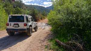 |
Waypoint 3 (37.7906, -112.8131)There's a creek crossing here. |
 |
Waypoint 4 (37.7906, -112.8130) |
 |
Waypoint 5 (37.7906, -112.8130) |
 |
Waypoint 6 (37.7906, -112.8129) |
 |
Waypoint 7 (37.7855, -112.8050) |
 |
Waypoint 8 (37.7855, -112.8050) |
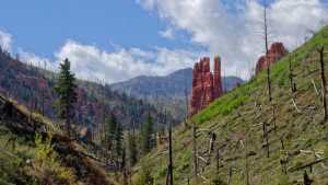 |
Waypoint 9 (37.7557, -112.7927)The trail passes through an area burned in the 2017 Brian Head Fire. |
 |
Waypoint 10 (37.7505, -112.7920) |
 |
Waypoint 11 (37.7495, -112.7913) |
 |
Waypoint 12 (37.7367, -112.7941) |
 |
Waypoint 13 (37.7178, -112.7693) |
 |
Waypoint 14 (37.7178, -112.7693) |
 |
Waypoint 15 (37.7178, -112.7693) |
 |
Waypoint 16 (37.7178, -112.7693) |
 |
Waypoint 17 (37.6590, -112.7451) |